See Your Farm From the Sky — Tree Count, Aerial Photos & Health Report
Whether you're managing 2 acres or 20 — or living away from your farm entirely — get a clear aerial view of your own areca plantation — colorful photos and video, an approximate tree count, and highlights of trees that look weak or stressed, so you know exactly where to focus attention on the ground.
One Flight, A Clearer Picture of Your Whole Farm
Walking your plantation row by row only shows you what's directly in front of you. A drone survey gives you the whole farm at once — count your trees, see the aerial layout, spot patches that look weaker than the rest, work out how much empty space you have for new planting, and keep a digital, geo-referenced record of your farm you can browse the way you'd browse Google Maps or Earth. Book a follow-up survey a few months after applying manure or pesticide to the flagged trees, and compare how they've responded.
Count
Approximate total tree count for your farm.
See
Colorful aerial photos and video of the full plantation.
Spot
Trees or patches that look weak or stressed, flagged for a closer look.
Digitize
A geo-referenced record of your farm you can keep and revisit.
You Don't Have to Be There
Working in another city, another state, or another country? You don't need to visit your farm yourself to know how it's doing. Just share your farm's location with us — a Google Maps pin, GPS coordinates, or even landmark directions are enough — and we take care of the rest.
Ideal for NRI farm owners, absentee landlords, and anyone managing a farm remotely.
Simple, Upfront Pricing
Choose the level of detail you need. Both packages cover up to 2 acres at the listed price.
- Colorful aerial photos of your farm
- Aerial video of your farm
- Approximate total tree count
- Highlights of visually stressed trees
- Farm digitization & mapping
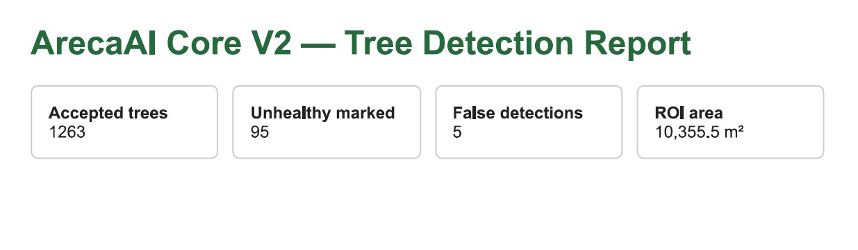
- Detailed report with health insights
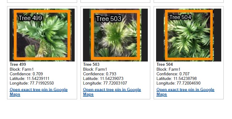
- Individual photos of unhealthy trees, with tree number
- Exact GPS / Google Maps location for each unhealthy tree — track and revisit individually
- PDF report with maps & photos
- 📍 If your field or farm is spread across different locations, extra charges apply for additional travel and processing.
- 💰 All prices are inclusive of the drone survey, processing and standard reporting.
- ⏱️ Reports are normally delivered within 48 hours (about 2 days) after the survey is complete, depending on workload — you don't need to be present, just share your farm's location with us.
- ⚠️ Visually stressed / unhealthy-tree highlights are flagged for field inspection — not a disease, pest or nutrient diagnosis. See the disclaimer below.
What You'll Actually Get
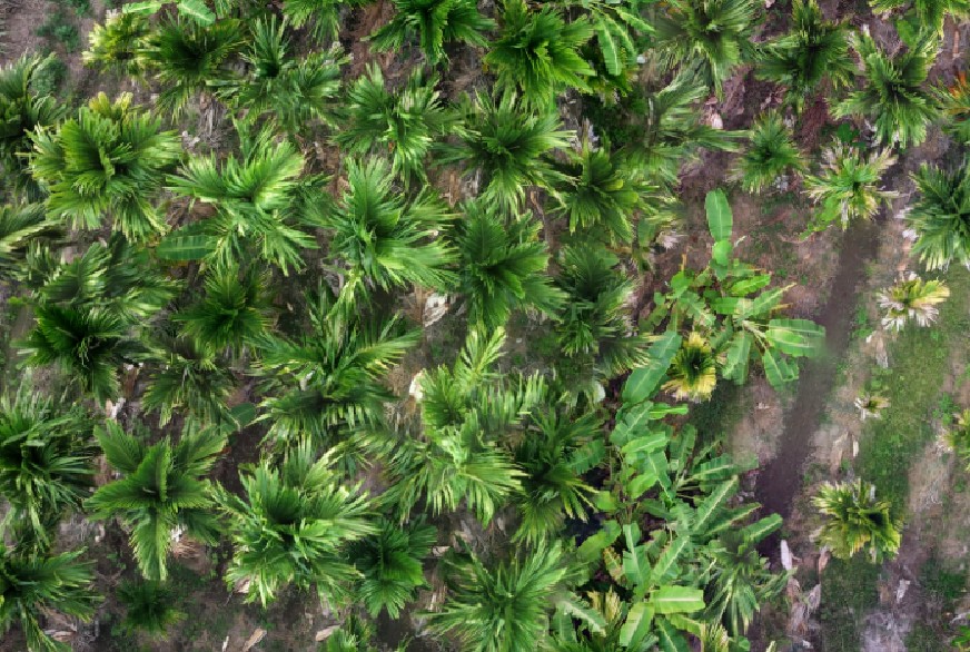
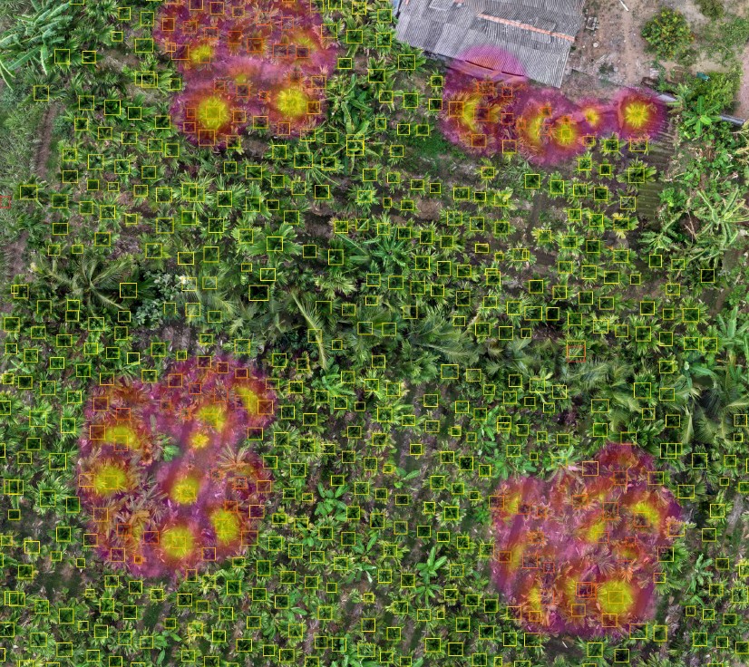
Every photo below is a real KITE Agro drone capture from an actual survey — not an illustration.
- 🎨 Colorful aerial images
Real photographs of your plantation from directly above. - 🔢 Tree detection & numbering
Advanced package — every counted/flagged tree gets an ID. - ⚠️ Stressed-area highlights
Advanced package — patches that look different from healthy canopy.
Our Pricing Pamphlet
The same Basic/Advanced pricing above, as a shareable one-page pamphlet.

If you're about to pay an advance for a harvest lease rather than surveying land you already own, see Areca Farm Lease Inspection instead — same underlying drone survey, packaged for that decision, with pricing quoted individually for your farm size.
Areca Drone Survey — Answered
How much does an areca drone survey cost?
Introductory pricing: Basic (aerial photos and video) is ₹3,999 for up to 2 acres, plus ₹1,499 per additional acre. Advanced (adds tree count, stressed-tree highlights, farm digitization and a detailed PDF report) is ₹6,999 for up to 2 acres, plus ₹2,499 per additional acre. Farms split across different locations incur extra travel/processing charges. Prices include the survey, processing and standard reporting.
What is the difference between the Basic and Advanced drone survey?
Basic gives you aerial photos and video only. Advanced adds an approximate total tree count, visually-stressed-tree highlights, farm digitization and mapping, a detailed PDF report, and individual photos of unhealthy trees with their tree number and exact GPS/Google Maps location so you can track and revisit them.
Can I use this to count how many areca trees I have?
Yes — the Advanced package includes an AI-assisted approximate total tree count from the aerial imagery, with human review. It's an approximate visible count, not an exact certified one, since dense canopy overlap or cloud cover during the flight can affect what's visible.
Can the drone tell me which trees are diseased?
No. The survey highlights trees or areas that look visually stressed compared to surrounding healthy canopy. It does not diagnose a specific disease, pest or nutrient deficiency from the air — that needs physical field inspection. See our Disease Guide and Pest Guide for ground-level guidance.
Can I check the same trees again after treatment?
Yes — many farmers book a follow-up survey a few months after applying manure, fertilizer or pesticide to the flagged trees, to visually compare how they're responding. Each survey is a fresh snapshot; book a repeat one any time you want an updated record.
Is this different from Areca Farm Lease Inspection?
They use the same underlying drone survey. This page is for farmers surveying land they already own. Areca Farm Lease Inspection is the same service packaged for someone evaluating a farm before paying a lease advance, with pricing quoted individually.
I live abroad or in another city — do I need to be present for the survey?
No. Just share your farm's location with us — a Google Maps pin, GPS coordinates, or address is enough. We schedule and fly the survey, and normally deliver your report within 48 hours (about 2 days) after the survey is complete, depending on workload.
KITE Agro's drone survey is a decision-support service based on aerial visual analysis. Tree counts are approximate and may require human review. Visually stressed / unhealthy-tree highlights indicate locations that may require field inspection and do not constitute disease, nutrient or pest diagnosis. Pricing shown is introductory and may change; final pricing for farms with unusual layout or multiple locations is confirmed before booking.
Ready to See Your Farm From the Sky?
Book a drone survey, or ask a question first on WhatsApp — no pressure, no obligation.