Leasing an Areca Farm? Inspect It from the Sky Before Paying the Advance.
Get a complete aerial view of the plantation with colorful images, aerial video, AI-assisted approximate tree count, potential gap identification and visual tree-health screening — so you know what to check on the ground before you commit a large advance.
Don't Lease a Farm Blindly.
See it. Count it. Map it. Inspect it. Then decide.
KITE Agro provides an additional layer of visual information to support your own physical farm inspection — not a replacement for it.
A Better Way to Inspect a Plantation With Hundreds of Trees
A prospective lessee is normally asked to pay a substantial advance and may only be able to inspect the farm by walking through it once or twice. When a plantation has hundreds or thousands of trees, it's genuinely difficult to judge the actual visible tree population, missing trees, empty spaces, plantation density, weak-looking areas, or how different parts of the farm compare to each other — just by walking the rows.
KITE Agro's drone gives a complete aerial view of the plantation, while AI-assisted analysis helps organise and interpret what's visible in that imagery — an additional digital layer of information alongside your own eyes on the ground.
SEE
Complete aerial view with colorful images and video.
COUNT
AI-assisted approximate visible tree count.
FIND
Potential missing-tree locations and plantation gaps.
SCREEN
Highlight visually stressed trees/areas for field inspection.
RECORD
Create a digital aerial record of the plantation.
COMPARE
Repeat mapping every few months to see visible changes.
In most areca farm leases, the farmer/owner continues maintaining the plantation year-round — irrigation, fertilizer, pest and disease management, labour. The lessee pays for that year's harvest rights, not for taking over farm management. So for a lessee, this inspection is mainly about the visible tree count, plantation condition and yield-relevant information going into that year — not about planning fertilizer or spray schedules, which stay the farmer's responsibility.
See the Entire Farm from Above
Drone inspection gives you a complete aerial view of the plantation that's difficult to understand while walking only at ground level — colorful aerial images, detailed top-view shots, aerial video, the visible plantation layout, tree distribution, and how different parts of the farm compare to each other.
- 🎨 Colorful, clear aerial images
Real photographs, not diagrams — see the plantation the way it actually looks from above. - 🎥 Aerial video
A flying overview of the farm, useful to review later or share with family/partners before deciding. - 🗺️ Visible plantation layout
Row spacing, density, and how different blocks of the farm compare.
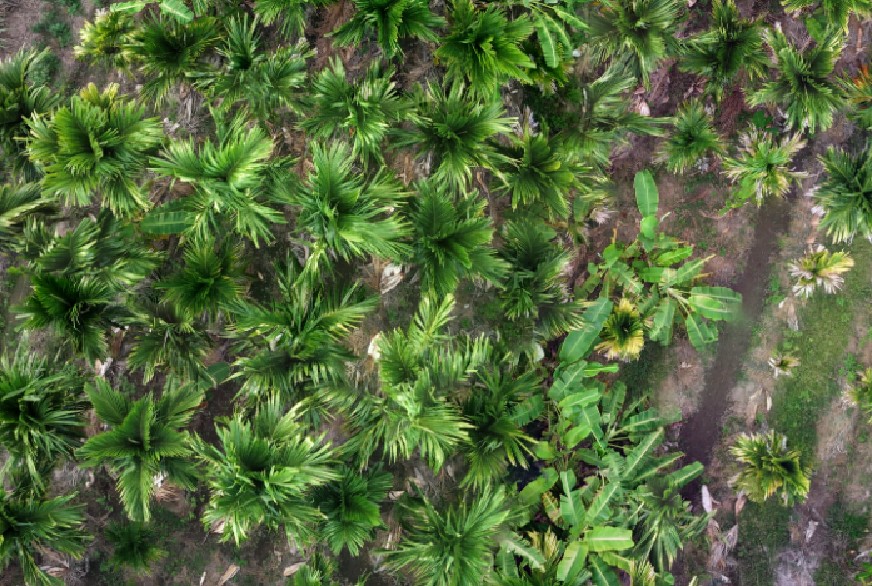
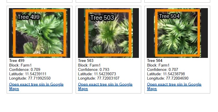
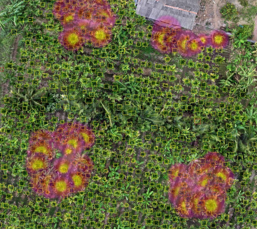
Real KITE Agro drone captures — not illustrations.
Know Approximately How Many Trees Are Present
KITE Agro's AI-assisted workflow identifies and counts visible areca trees from the aerial imagery, with human review of the results. This gives you an AI-assisted approximate tree count — not a claim of 100% accuracy, since dense canopy overlap, young palms hidden under older fronds, or cloud cover during the flight can affect what's visible in any single scan.
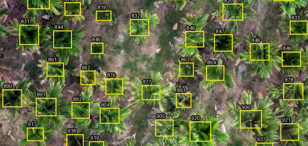
A prospective lessee is often told, verbally, that a farm has "approximately 2,000 trees." Instead of relying on that claim alone, an independent aerial assessment of the visible tree population gives you additional information for verification and negotiation. This does not certify the owner's claimed count — it's one more data point to weigh alongside your own inspection.
Find Missing Trees and Potential Planting Gaps
KITE Agro can highlight plantation areas where trees appear to be missing — gaps in otherwise regular planting rows, vacant positions, and potential locations for future replacement planting.
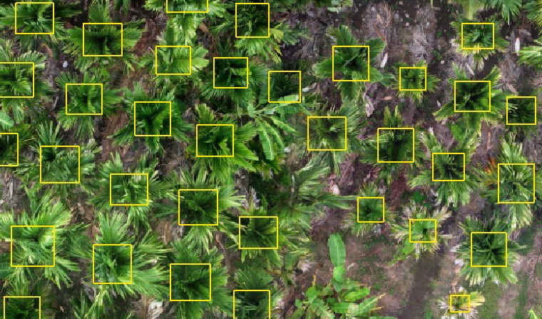
Not every empty area needs a new tree — suitability depends on field conditions (paths, drainage channels, structures, soil). Gaps are flagged for verification, not treated as an automatic planting recommendation.
Find Trees That Deserve a Closer Look
KITE Agro can visually compare tree appearance across the plantation and highlight trees or areas that look different from the surrounding healthy-looking vegetation — sparse-looking canopy, poor canopy growth, unusual appearance, or reduced visible greenery. These are marked Visually stressed — field inspection recommended.
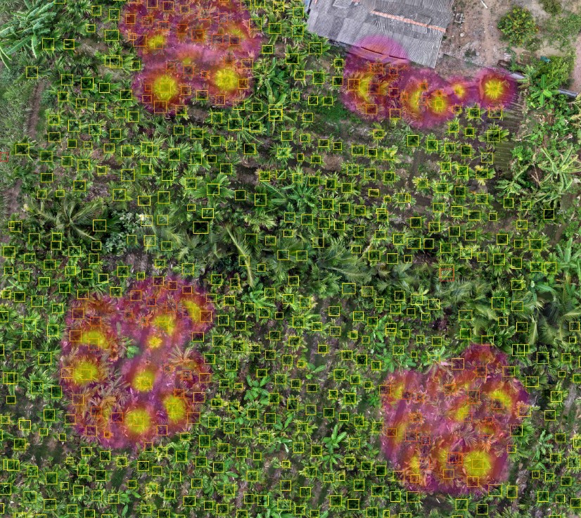
The aerial analysis can highlight trees or areas that appear visually stressed. The actual cause should be determined through physical field inspection before deciding on treatment. KITE Agro never states that a drone has "detected" a specific disease, pest, or nutrient deficiency — for symptom-based, ground-level guidance, see our Disease Guide and Pest Guide.
The Strongest Method Is Both Together
Drone inspection doesn't replace walking the farm — it tells you where to walk more carefully.
Create a Digital Record Before Taking the Farm on Lease
The aerial images, video and inspection output give you a visual record of how the plantation looked at the start of the lease — useful later for comparison as the lease progresses.
Digitize the Farm Every Few Months
After taking the farm on lease, you can repeat aerial inspection periodically. This can help track visible changes such as:
We don't promise automatic, exact change-detection between surveys unless that functionality is actually enabled for your account — periodic mapping today means a fresh visual record each time, compared manually.
Useful After Leasing Too
Under a typical harvest lease, the farmer/owner keeps maintaining the plantation — the lessee is paying for that year's harvest, not taking over farm management. Periodic mapping still helps a lessee: track the visible tree count and canopy condition the year's yield depends on, verify the plantation is being maintained as agreed, spot areas that look weaker so you can raise it with the owner early, and go into next year's lease negotiation with a real record instead of just memory.
If one part of the plantation consistently looks weaker in the aerial imagery, you can inspect that area more closely on the ground and decide whether manure, fertilizer, irrigation, pest management, disease management, or another intervention is actually needed. KITE Agro doesn't tell you where fertilizer is deficient or which pesticide to spray from the air — the drone points you to where to look; the field inspection (and, where useful, our free calculators below) helps you decide what to do. If you're leasing for the harvest rather than maintaining the farm, flag weaker-looking areas to the owner instead — upkeep is typically their responsibility.
Before Leasing an Areca Farm, Check
A practical checklist — useful whether or not you book a drone inspection with us.
Who Should Use This Service?
Prospective Farm Lessee
Inspect before committing the advance.
Existing Farm Lessee
Digitize and monitor the plantation periodically.
Farm Owner
Maintain a plantation record and tree inventory.
Buyer / Investor
Gain an additional visual overview before further due diligence.
Farm Manager
Prioritize field inspections across large plantations.
What the Customer Receives
Depending on the KITE Agro package you choose, deliverables may include:
- 🖼️ Complete aerial view of the farm
Colorful aerial images and detailed top-view shots. - 🎥 Aerial video
A flying overview of the plantation. - 🔢 Approximate visible tree count
Plus a tree detection map where available. - 🕳️ Potential missing-tree / gap locations
Flagged for your field verification. - ⚠️ Visually stressed tree/area highlights
Marked for closer physical inspection. - 🗺️ Plantation overview & digital inspection report
Selected annotated images included. - ✅ Recommendations for areas requiring ground inspection
So you know exactly where to walk more carefully.
Pricing depends on acreage and tree count — contact us on WhatsApp or phone for a quote for your specific farm.
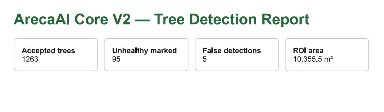
Sample Report
An illustrative layout using example figures — not an actual customer result.
Every aerial photograph on this page is a real KITE Agro drone capture — not a stock photo or an AI-generated illustration. As we complete more farm-lease inspections, we'll add real case studies and reports here.
Farm Lease Inspection — Answered
How can I check an areca farm before taking it on lease?
Combine a physical walk-through with an aerial drone inspection. The drone gives you a complete overhead view, an approximate visible tree count, potential missing-tree/gap locations and areas that look visually stressed — information you then verify on the ground, alongside checking irrigation, yield history and legal/ownership documents before paying any advance.
How do I know approximately how many areca trees are in the farm?
KITE Agro's drone survey captures the full plantation from above, and an AI-assisted workflow identifies and counts visible areca palms in the imagery — giving you an approximate visible tree count rather than relying only on the owner's verbal claim. This is additional information for verification and negotiation, not a certified legal count.
Can a drone count areca trees?
Yes, approximately. AI-assisted detection can identify most visible tree canopies in a scan, with human review of the results. Dense canopy overlap, young palms hidden under older fronds, or cloud cover during the flight can affect accuracy — so the figure is an approximate visible count, not an exact one.
Can drone inspection find missing trees?
It can highlight areas where trees appear to be missing along a planting row or vacant positions in an otherwise regular layout. These are flagged as potential planting locations for field verification — not a guaranteed dead/removed-tree count, since some gaps are intentional (paths, channels, structures).
Can drone inspection identify weak trees?
The aerial analysis can visually compare canopy appearance across the plantation and highlight trees or patches that look different from the surrounding healthy-looking vegetation. These are marked visually stressed and worth a closer look on the ground.
Can a drone diagnose arecanut diseases?
No. It can highlight visually different or stressed trees and areas, but specific disease diagnosis requires physical field inspection. For symptom-based guidance once you're on the ground, see our Disease Guide and Pest Guide.
Is drone inspection enough before leasing farmland?
No. It should complement — not replace — physical inspection, yield verification, irrigation inspection, and owner/document/legal due diligence.
Why should I map a leased farm periodically?
Repeating the survey every few months creates a visual record of the plantation over time — useful for tracking visible changes and keeping a farm record independent of memory or verbal reports.
KITE Agro's drone farm inspection is a decision-support service based on aerial visual analysis. Tree counts are approximate and may require human review. Visually stressed areas indicate locations that may require field inspection and do not constitute disease, nutrient or pest diagnosis. Prospective lessees should independently verify farm ownership, legal documents, irrigation, yield, crop condition and lease terms before making financial commitments.
Inspect Before You Invest in the Lease
Book a drone farm lease inspection, or reach out with any questions first — no pressure, no obligation.